
I watch every race and see SOLers end up in totally avoidable BBQ situations. So how do you avoid them? Continue reading Reliably Avoiding DC BBQs
SOL Memoralia
A long time ago sailonline had an online shop, selling things like mugs and t-shirts with a sailonline logo. Now, after long time, it is possible to get the real gear and mandatory items for the armchairsailor via an online shop again! Even better, there are two shops available, depending on where you are in the world, one might have better shipment costs than the other, but be sure to check out both, some items may only be available in one shop! Continue reading SOL Memoralia
It doesn’t get easier, only faster
Four years of boat outlaw in SOL. Let’s look back at the past and current editions of my favourite race.
DC Checker, Editor, Grib Loader and more. Now with BBQ Rescue.
The next installment has arrived! A series of significant enhancements including a graphical DC checker. Continue reading DC Checker, Editor, Grib Loader and more. Now with BBQ Rescue.
Ocean racing along the latitude parallels
This is not really a report on my Geraldton-Cape Town race so much as some observations on SOL ocean racing which hopefully might lead to some conversations on the Solfans blog and Sol chat.
I have promised to do a Pilot Charts routing before each race to show what, according to the ‘most likely’ reading of the Pilot Charts for the location and time and year we are racing, would be the ‘most likely’ quickest course.
This is of course not likely to be the course any of us might actually sail because we’ll be racing in ‘real weather’, and not ‘most likely’. However, even from this second race where I have compared the Pilot Charts course with the actual, there are some interesting observations to make. Continue reading Ocean racing along the latitude parallels
Routing Based On Pilot Charts – Geraldton to Cape Town preview
It seemed to me that as a part of course pre-planning for long ocean races, it might be useful if I published on Solfans for each new SOL ocean race the suggested OpenCPN routing based on Pilot Chart wind data for people to make use of if they so desired. It also seemed that it might be a useful resource for the non-routers out there.
Here is that route for the upcoming Geraldton Cape Town race.
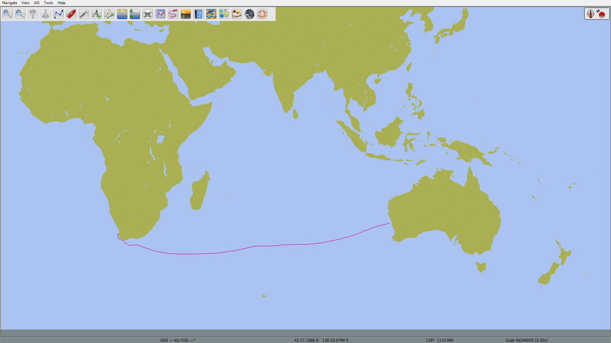
I have run a route on my own router using the SOL grib data and superimposed that for comparative purposes. The suggested Pilot Chart routing for March is the pale pink line and the routing using SOL and NOAA extended grib data as at the 22:30 WX on Feb 28 is the deeper pink line with the wind direction barbs attached. You can see that the primary difference is that the current weather data suggests a much more northerly route than the Pilot Charts suggest, principally because of a significant high currently lying west of Perth.
The OpenCPN Pilot Chart route suggests a trip of 18 days 8 hours, and the route using SOL weather suggests 14 days 13 hours. In other words, we can expect a faster than average trip.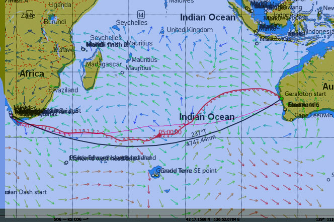
Continue reading Routing Based On Pilot Charts – Geraldton to Cape Town preview
Automatic Grib Downloader and DC Editor
Ever sat there waiting for the grib to arrive? Want the grib on your computer ready to use? I’ve written a Java utility that will monitor the SOL server and automatically download the grib file for you when it arrives. It’s been enhanced to include a DC editor and now has a graphical interface. Continue reading Automatic Grib Downloader and DC Editor
Bi-Linear and Linear Interpolators For Excel
Want to work out your performance loss for a tack / gybe or expected boat speed from TWS and TWA in Excel. Then you need to have a look at this. Continue reading Bi-Linear and Linear Interpolators For Excel
Her name is Rio
BA to Rio is neat short ocean race, and had been on my todo list for a long time. It is a bit too coastal for my tastes, so I only made my go decision very late.
Well Filtered Caribbean Rum
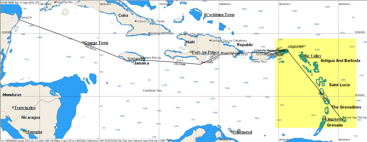 The course of the Caribbean Rum Run stretches from the Barbados in the east to Cancun in the west. While the an aggregate rhumb-line of the race almost 1800 nm — much longer when measuring ‘on the water’ distance — it is convenient to look at the run as a series of short races. Each of these short races acts on the SOL fleet like a filter. Each filter presents a different challenge. The first challenge is passing through the Windwards Islands. Continue reading Well Filtered Caribbean Rum