
Hitting islands is an easy and entirely too common way to ruin your race. The best SOLers do it once in a while. And of course there was the much talked about Vestas grounding. So how do we avoid this?
First off, no, Team Vestas were not taking any ‘risks’. To hit a fairly wide reef right in the middle, they had to be blissfully unaware of the obstacle.
A major question was how software should have prevented the grounding. In my opinion, not at all. In this kind of situation one should do a clean route without obstructions, it’s the navigators job to identify any obstacles.
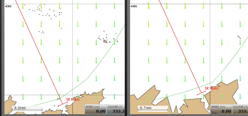
The first reason is that projected routes aren’t super accurate. If the calculated ‘optimum’ route intersects an island 12h out, that means exactly nothing. 6h is accurate in SOL, no so much IRL. In Punta-Fort Lauderdale I tracked the possible spots for crossing the Antilles (around 13N 61W), over a couple days the different ‘optimum’ routes had covered nearly a 100nm range! And this in a race with no corrections at the wx whatsoever. Software routing around islands introduces a lot of noise, nothing more.
Second, I would not trust software at all. You might get a route that avoids the land polygons, but what about wind shadow, shallows, waves, cardinal marks etc? Would software allow the pictured route? I don’t want to find out.
Third software routers are in fact poorly equipped for the best track around islands. Every router in existence is grid based, islands never lie exactly on the grid. I suppose one could create a perfect maze router, but for good reason nobody cares to do it.
Finally it’s rather trivial to steer around an island a couple hours away, so long as you know it’s there…
Now it’s obvious that the human navigator must follow a protocol to spot islands in time. We don’t know why the protocol broke down for Vestas, the main assumption being zoom-level weirdness, but it’s all speculation for now. Let’s look at the much less strict SOL protocol instead:
Inspect the start, finish and waypoints at a high zoom level.
Generally be aware where the islands are.
At the wx, look for any obstacles near your predictor line.
Whew, it’s not that hard. Thankfully the GSHHG charts that SOL uses don’t have any big surprises at higher zoom levels.
Usually.
Some minor points…
The trick for getting a clean route in BWR is to put the start point on land, I sometimes go out of my way to do this.
If the optimum route cuts across land, or inside a WP, this means one has to get as close to the coast as possible. OTOH the fastest route might be clear anyway, but it would not be obvious when routing with boundaries.
The computing time scales with the weather area. This means that SOL grib + BWR is a bad idea, moreso if land boundaries are ignored. One needs to use either a custom sized 3rd party grib (like zygrib) or trim the SOL gribs in BWR. I do both.
Hi!
Very interesting, but I realize that I have to study more… Some of the abbreviations are not (yet) known to me, but that’s only me
Thanks for your efforts – hopefully I’ll get a bit better, in the end!
M
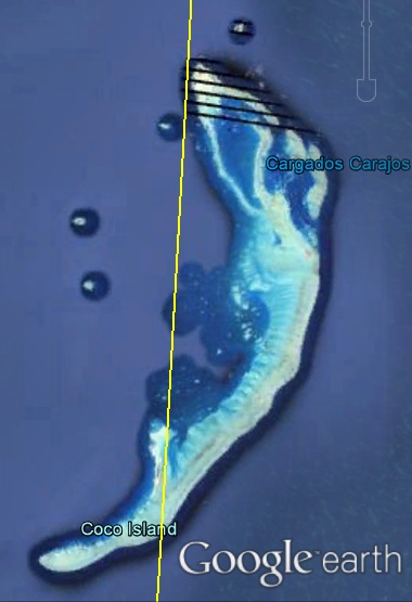
Exception made to Vestas and SCA, all the boats went to West of the fatidic “rock”. But even SCA did their route with a safety margin to the rocks (pls, have a look on http://www.volvooceanrace.com/en/dashboard/leg2.html ).
I have to assume (rules oblige) that the routing software in all the VOR boats was/is equal and the same for the electronic and paper charts.
In relation to Vestas remains the question: if all the others saw in advance and avoided the approaching rock zone, why Vestas went confidently for it?
Seems to me that the software worked for the majority, not for Vestas. Why?
See the full report of vestas here: http://www.volvooceanrace.com/static/assets/content_v2/media/files/m36616_team-vestas-wind-inquiry-report-released-on-9-march-2015.pdf
Boats do not necessarily have the same software or charts, but Vestas has the same software as others, and because there’s probably not much options, also a lot of the same charts. They had a different set-up though: routing on one laptop, navigation on the other.
As always, it was a combination of factors. The three things that stood out for me were:
– Race control announced that boats were allowed in that area of the course very late, at a time that the on-board navigators were not supposed to discuss navigational things with their team.
– The detailed charts were on the navigation laptop, but for that night, only the routing laptop was used to check for what’s to come.
– The less detailed chart contained no indication what so ever that there might be a huge island (with buildings on it!). I would expect at least some indication, since the chart was still somewhat detailed.